








Interactive Warhammer 40,000 Galaxy Map Launched with M41 and M42 Chronicles, Planet Dossiers, and the Great Rift
 ·
30.08.2026 15:14
·
3 min read
·
30.08.2026 15:14
·
3 min read
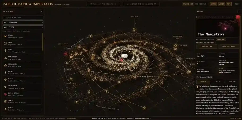
Enthusiasts have launched Cartographia Imperialis, a large-scale interactive atlas for the Warhammer 40,000 universe styled after an Adeptus Mechanicus terminal. Designed like Google Maps for the grim darkness of the far future, the project lets users explore Imperium sectors, xenos domains, and warp anomalies, as well as track the galaxy’s catastrophic changes during the transition from the 41st to the 42nd millennium.
Epoch Switch: The Galaxy Before and After the Great Rift
The main technical feature of the service is the ability to dynamically switch between two historical layers:
- M41 Pre-Rift: The state of space prior to the devastating events of the 13th Black Crusade;
- M42 Indomitus: The current chronological era following the opening of the Great Rift (Cicatrix Maledictum).
The toggle changes not only visual borders but also the status of locations. For instance, in the M41 layer, the legendary fortress world Cadia is marked as a key bastion near the Eye of Terror, while in M42 it appears as a destroyed world.
In its Great Rift guide, the service demonstrates the division of humanity’s domains into Imperium Sanctus, bathed in the light of the Astronomican, and Imperium Nihilus, severed from Terra by pitch darkness.
Location Dossiers: Atlas and Encyclopedia in One Interface
Clicking any point opens a detailed object dossier. It includes:
- Affiliation with one of the five segmentums (Segmentum Solar, Ultima, Obscurus, Tempestus, Pacificus);
- Planet type (hive world, forge world, tomb world, agri-world, among others);
- Current faction control;
- Detailed combat history and lore breakdown.
The Terra dossier details the Emperor’s palace and the inner workings of the Astronomican, the Sota page documents the tragedy of the Scythes of the Emperor chapter, and the Pariah Nexus entry explains its transformation into a battlefield against awakening Necrons.
Filters, Routes, and 52 Key Locations
According to the Cartographia Imperialis world and region archive, the map already includes 52 core lore locations: from the Sol system (Sol) and the T’au Empire to the dark Eldar city of Commorragh in the Webway and the hazardous fringes of the Ghoul Stars (Ghoul Stars).
The top control panel features layer switches:
- Routes — Displays key space lanes and trade routes;
- Labels — Enables sector text labels;
- Rift — Outlines warp storms and rifts;
- Overlay — Provides an auxiliary coordinate grid.
Cartographic Methodology and Fan Precision
In the project methodology page, the developer clarifies that the service is an independent fan project. Games Workshop has never published a mathematically precise coordinate system for 40K, and codex illustrations across different editions occasionally contradict one another.
Therefore, the author calculated world positions based on relative proximity, mentions in canonical literature, and established astrographic landmarks. As new material is released, the project database on the official Cartographia Imperialis website is regularly updated with new worlds and thematic sector guides.