








NASA Tests Autonomous Landing System That Finds Safe Ground on the Moon and Mars by Itself
 ·
25.09.2026 18:38
·
4 min read
·
25.09.2026 18:38
·
4 min read
NASA has successfully completed a new round of testing for SPLICE (Safe and Precise Landing – Integrated Capabilities Evolution), a suite of technologies for autonomous, high-precision landings on the Moon, Mars and other celestial bodies.
In August 2026, the hardware was mounted on an Alta-X drone and flown in California on flights that simulated the final stages of a lunar descent. According to NASA, the system successfully carried out the simulated descent and landing maneuvers.
What set these tests apart was a closed-loop control system: the navigation system did not simply record data for later analysis but used it in real time during flight to determine its position and adjust its trajectory.
There is an important caveat, though: the August flights focused primarily on testing Dual Quaternion Guidance (DQG) and Active Terrain Relative Navigation (ATRN). Other SPLICE elements, including the hazard-detection lidar, underwent separate flight tests earlier.
The system decides for itself where it is safer to land
SPLICE combines several technologies at once: cameras, lidars, a powerful onboard computer, and algorithms for navigation, terrain recognition and trajectory control.
Terrain Relative Navigation (TRN) photographs the surface during descent and matches the images against preloaded orbital maps. That lets the spacecraft determine its position relative to craters, highlands and other landmarks without any input from an operator on Earth.
Navigation Doppler Lidar (NDL) uses lasers to measure distance to the surface and the spacecraft’s velocity. NASA notes that it delivers significantly more accurate measurements than traditional radar sensors while being smaller, lighter and less power-hungry.
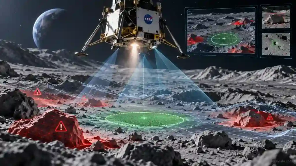
In the final stage, Hazard Detection Lidar (HDL) kicks in. At an altitude of about 500 meters, it scans the surface and builds a detailed three-dimensional map of the terrain.
The onboard computer analyzes that map, identifies large rocks, steep slopes and other hazardous areas, and then picks a safe landing spot within an area about 100 meters across. If the original target turns out to be unsuitable, the guidance algorithms can plot a new trajectory to a safer location.
15 million laser pulses in a matter of seconds
In March 2025, NASA separately tested Hazard Detection Lidar from a helicopter over a simulated site at Kennedy Space Center.
The lidar can map an area roughly the size of two football fields in just two seconds, processing about 15 million short laser pulses.
The resulting 3D map is sent to the Descent and Landing Computer, which assesses the terrain and selects a suitable landing site.
This approach matters most in areas where sending spacecraft with traditional navigation systems would be too risky — for example, regions near craters, large boulders or permanently shadowed parts of the Moon.
The technology could be used on Mars and icy worlds
SPLICE is not being developed for lunar missions alone. NASA is looking at using individual components of the suite on Mars, icy moons and other bodies in the solar system.
The technologies have also been studied in the context of Commercial Lunar Payload Services, potential Mars missions and other future landers.
The SPLICE project itself kicked off in October 2017, though some of the technologies it uses appeared even earlier and were tested on suborbital rockets, helicopters and ground rigs.
The August 2026 flights were one of the program’s final stages. NASA’s roadmap has SPLICE wrapping up in September 2026, after which individual sensors, algorithms and computing solutions can move into future missions.
SPLICE’s main advantage is that a lander can assess the terrain on its own during descent and steer clear of hazards instead of relying solely on a pre-selected touchdown point. That could open up parts of planets and moons previously considered too difficult for a safe landing.